Wednesday, May 20, 2015

Coins & Currency in Sri Lanka!


Coins are some of the oldest artifacts that reveal the history of our past. Numismatics covers the
collection and study of coins, tokens and currency of all ages.
Lanka has a very rich and documented numismatic history stretching back over 2300 years. The earliest
known coins mentioned in the 3rd Century Chronicle Mahavamsa are Karshapana. These are small flat silver pieces about three grams in weight on which various marks have been punched. Most came from
India in trade, but some may have been manufactured in Lanka.
The first indigenous coins of Lanka issued during the early Anuradhapura period have the railed
swastika which is found only on Lankan coins. The largest of these coins known as the Elephant and
Swastika has multiple symbols. Smaller coins have the Bo tree, or a lion, or Gaja Lakshmi on the
reverse and the railed swastika on the obverse.
The Kahavanu which were issued in the 7th to 11th century are about 4.4 grams of typically 9-15 Karet
gold and are also found as fractions Pala (Quarter) and Aka (Eighth) of a Kahavanu. Similar sized
copper coins known as Massa issued from 9th to 13th centuries had the name of the king written in Nagri
text.
Coins were also issued by the colonial rulers, the Portuguese, Dutch and British for use in Lanka. During
the British period from about 1840 to 1880, tokens were used in coffee and tea estates as payment for
labour. The tokens were redeemable only at the company shop for goods creating a closed economy.
The first rupees and cents coins are dated 1870 and have the head of Queen Victoria. Similar coins
in copper and silver were issued with the heads of Edward VII, George V, George VI and Queen
Elizabeth II. Coins with the Ceylon Armorial emblem were issued from 1963 to 1972, and the Sri
Lanka Armorial Emblem since 1972. The Central Bank has also issued commemorative coins since
1957, some of which circulated, and can be found among the change you get.
(All coins and currency are displayed at actual size.
Background water mark - One Pound Sterling 1827-1853 / Fifty Rupees 1941-1945).
52 | Coins and Currency of Lanka SLT RAINBOW PAGES
Lankan currency notes have a rich history of over 200 years. The oldest notes issued by the Dutch
in 1785 were known as Kredit Brieven. The British issued Sterling currency from 1827 and many
international banks operating Lanka issued currency as well. From 1885 there was rupee currency
from the Ceylon Government, and since 1951 from the Central Bank.
There are a number of Coins and Currency Collections, like those in the Colombo and Kandy National
Museums, the Dutch Period Museum, the Central Bank Economic History Museum, the Bank of
Ceylon Museum which are open to public.


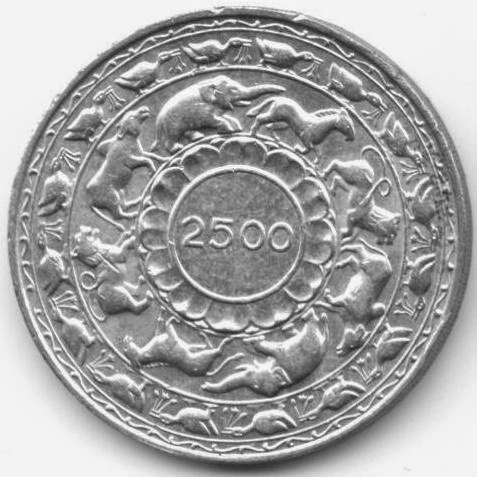


The market value of a coin or currency depends strongly on its rarity and condition. Punch Mark
coins about 2000 years old may sell for little more than their weight in silver. Most copper Massa
coins which are over 800 years old and VOC duits which are over 200 years old may be obtained for
around Rs 100 since they are found in very large numbers. There are, however, a few Lankan copper
coins that are worth a lot more than their weight in gold.
Crude replica of the VOC bar, Dutch and early British dump coins are sold by street hawkers in
Galle Fort and other tourist spots. There also some replica, which need an expert knowledge
to identify.

Note that it is also illegal to export out of the island any genuine antique item including
coins more than 100 years old. The Sri Lanka Customs have recently opened a museum
with the best of these confiscated items including coins.Technically modern fakes are
OK, but the Sri Lanka Customs Officers at Airport or Post Office will not probably
identify them as such, and if discovered will give you as much problems as the genuine
article until you can prove they are fake.


The Sri Lanka Numismatic Society (SLNS) was founded in 1976 to serve the coin collectors
in Lanka and counts many leading collectors of coins and currency as members..
(The writer Dr Kavan Ratnatunga maintains an educational website on Lankan
coins and currency at http://coins.lakdiva.org which could be referenced for more
information).


Rainbowpages

Tuesday, April 7, 2015

Sabaragamuwa Province in Sri Lanka!


Sabaragamuwa, is a province of Sri Lanka, and contains two main cities: Ratnapura and Kegalle. Sabaragamuwa University is in Belihuloya. It is named after its former indigenous inhabitants, namely the Sabara, an Indic term for hunter gatherer tribes, a term seldom used in ancient Sri Lanka. Ratnapura is the name of the provincial capital of Sabaragamuwa Province is situated 101 km south east of Colombo; it is the centre of a long-established industry of precious stone mining including rubies, sapphires, and other gems. Apart from gem mining, the town is known for rice and fruit cultivations. There is a well-established tourism industry in Ratnapura. Sinharaja Forest Reserve, Udawalawa National Park, Kitulgala, and Adam's Peak are especially popular among tourists.

The people of the town depend on the gem trade. Gem pits are a common site in the surrounding area. Most of the large-scale gem businessmen operate from Ratnapura. There are considerable numbers of foreign gem traders in town too. Rice cultivation presently faces an uncertain future in Ratnapura because many farmers are giving up their rice cultivation and switching to gem mining which is a more productive way of earning money. Many delicious fruits like mango and papaya and vegetables are grown as market products.
Ratnapura is located in the A4 Highway which connects capital Colombo to Kalmunai in the Eastern Province. Another Highway A8 connects the town with Panadura in the western coast of Sri Lanka. Ratnapura features a tropical rainforest climate. The city is located in the south-western part of Sri Lanka, the so-called wet zone. The town receives rainfall mainly from south-western monsoons from May to September and is regularly flooded.  
There are many places of worship in and around the city. The mountain Sri Pada -Adam's Peak, Maha Saman Devale, Delgamu Viharaya, Pothgul Viharaya, Diva Guhava,  Siva Temple, Jumma Mosque, Saints Peter and Paul's and St. Luke's Churches.
The scenic nature’s creations are the water falls. Bopath Ella situated at Kuruwita, Katugas Ella; a popular water fall situated at Mahawalawatta, 3 km away from Ratnapura; Kirindi Ella; the seventh highest waterfall in Sri Lanka situated 4 km away from Ratnapura - Pelmadulla Main road; Rajanawa; situated next to Ratnapura Kalawana main road in Marapana village, this beautiful scenery been captured in few famous Sinhala films.
In the time of the Last king of Sri Lanka "Sri Wickrama Rajasinha", Ehelepola Nilame was sent to Sabaragamuwa (Ratnapura) as "Disawe" or local governor of Sabaragamuwa. He builds a small reservoir and water canal to support local rice farms. The works of this hero are still visible around the Ratnapura area and local people benefiting from his works even today. His house is used as the Local museum building. The portrayal of Ehelepola as a hero is quite controversial. Once he conspired with British and betrayed the Kandy king. The King ordered the execution of his family unless Ehelepola surrendered to the king. He did not give into emotions but stood by the people to oust the Nayakkar ruler. His younger son who understood the cause of his father bravely faced the executioner.  
Kegalle is a town in Sabaragamuwa Province of Sri Lanka. It is located on the Colombo - Kandy road. It is 78 km away from Colombo and 40 km away from Kandy. Kegalle is the capital of the Kegalle District which is one of the two districts of Sabaragamuwa province. The surrounding area produces graphite, precious stones and agricultural products such as rice. Kegalle has an agricultural based economy and mainly produces rubber. Nearby is the Pinnawala elephant orphanage which is a major tourist attraction.

District of Kegalle situated in between the central highlands and western southern planes and has an enchanting environment. Height of the western region is less than 500 feet from the sea level while eastern region exceeds 1000 feet. Rubber cultivation has stretched over most of the area of the District and minor export crops such as coffee, cocoa, pepper, clove and nutmeg takes an important place in its economy. Sri Lanka’s best graphite mine is sited at Bogala in Kegalle District. 


SLT Rainbowpages


Monday, March 30, 2015

Northern Province in Sri Lanka!

Jaffna the City of Jaffna is the capital city of the Northern Province of Sri Lanka. It is the administrative headquarters of the Jaffna district located on a peninsula of the same name. Jaffna is approximately six miles away from Kandarodai which served as a famous emporium in the Jaffna peninsula from classical antiquity. Jaffna's suburb, Nallur served as the capital of the four centuries-long medieval Jaffna kingdom. Prior to the Sri Lankan civil war, it was Sri Lanka's second most populated city after the commercial capital Colombo. Since the 1980s insurgent uprising, military occupation, extensive damage, expulsion and depopulation has happened. Since the end of civil war in 2009, refugees and internally displaced people are returning to their homes and government and private sector reconstruction has begun.

Historically, Jaffna has been a contested city. It was made into a colonial port town during the Portuguese occupation of the Jaffna peninsula in 1619. It changed hands to the Dutch colonials, who lost it to the British in 1796. After Sri Lanka gained independence 1948, the political relationship between the minority Sri Lankan Tamils and majority Sinhalese worsened. Black July erupted after the cold blooded killing of 13 soldiers. Jaffna was occupied by the rebel Liberation Tigers of Tamil Eelam (LTTE) in 1986 and the Sri Lankan military gained control in 1995.

Majority of the city’s population are Sri Lankan Tamils, although there was a significant number of Sri Lankan Moors, Indian Tamils and other ethnic groups present in the city prior to the civil war. Most Sri Lankan Tamils are Hindus followed by Christians, Muslims and a small Buddhist minority. The city is home to number of educational institutions established during the colonial and post-colonial perio
d. It also has number of commercial institutions, minor industrial units, banks, hotels and other government institutions such as the hospital. It is home to the popular Jaffna library that was burnt down and rebuilt. The city is anchored by the Jaffna fort rebuilt during the Dutch colonial period.  


Excavations that were conducted by Sir Paul E. Pieris during 1918 and 1919, that were utilised in the ancient Jaffna capital of Kandarodai and Vallipuram; a coastal town six kilometres from Point Pedro revealed coins called "puranas", and "kohl" sticks that dated back to 2000 B.C similar in style to the sticks used to paint pictures in Egypt, suggesting that the Northern part of Sri Lanka was a "flourishing" settlement prior to the arrival of Prince Vijaya In the chronicle Mahavamsa, around sixth century B.C, there are descriptions of exotic tribes such as the Yakkhas strictly inhabiting the centre of the island, and the Nagas who worshiped snakes inhabiting the Northern, Western and Eastern parts of the island, which was historically referred to as "Nagadipa". Jaffna city, along with the rest of the Jaffna peninsula was part of the Kingdom of Tambapanni in 543 BC. Ancient Sinhala chronicles including Mahavamsa describes Jaffna city as a vital part of the island nation. It briefly come under the rule of South Indian Kingdoms, after several incursions it has been recaptured by Sinhalese Kings thereafter, last of which was Parakramabahu VI.

The city is surrounded by Jaffna Lagoon to its west and south, Kokkuvil and Thirunelveli to the north, and Nallur to the east. Jaffna peninsula is made of limestone as it was submerged under sea during the Miocene period. The limestone is grey, yellow and white porous type. The entire land mass is flat and lies at sea level. Within one mile of the city centre is the island of Mandativu which is connected by a causeway. Palmyrah groves can be seen where land has not been used for construction.

Jaffna features a tropical rainforest climate with no true dry season month. Jaffna has the highest average temperature in Sri Lanka – 83 °F. The temperature is highest in the months of April – May and August – September. The temperature is coolest in December – January. The annual rainfall is brought in by the North East monsoon and it varies from one place to the other and also from year to year. The average rainfall is 50 inches in the western part of Jaffna peninsula. 

Since 5th Century BC, present day Mannar District was part of Rajarata until 13th Century AD. During the 15th Century AD and 17th Century AD it was ruled by Vanniar Chieftains who paid tribute to the pre-colonial Jaffna kingdom. The district then came under Portuguese, Dutch and British control. In 1815 the British gained control of the entire island of Ceylon. They divided the island into three ethnic based administrative structures: Low Country Sinhalese, Kandyan Sinhalese and Tamil. The district was part of the Tamil administration. In 1833, in accordance with the recommendations of the Colebrook-Cameron Commission, the ethnic based administrative structures were unified into a single administration divided into five geographic provinces. Mannar District, together with Jaffna District and Vanni District, formed the new Northern Province

At the time that Ceylon gained independence, Mannar was one of the three districts located in the Northern Province. Mantai East division was transferred to newly created Mullaitivu District in September 1978. Much of Mannar District was under the control of rebel Liberation Tigers of Tamil Eelam for many years during the civil war. The entire district was recaptured by the Sri Lankan military in 2008.
Mannar Island is also notably one of the few places in Sri Lanka where Baobab trees thrive. The Baobab tree, native to Africa, was bought by Arab sailors to feed camels which they stationed in the area. Although camels are not found in today, few Baobab trees still thrive on the hot sandy Mannar region. It appears strange and barrel-like enormous trunk, which tapers into branches. When the leaves are shed, the tree gives the impression that it had been planted upside down. 


Wednesday, March 11, 2015

North Western Province in Sri Lanka

North Western Province is a province of Sri Lanka. The districts of Kurunegala and Puttalam formulate Wayamba. Its capital is Kurunegala, which has a population of 28,571. The province is known mainly for its numerous coconut plantations. Other main towns in this province are Chilaw (24,712) and Puttalam (45,661), which are both small fishing towns. The majority of the population of Wayamba province is of Sinhalese ethnicity. There is also a substantial Sri Lankan Moor minority around Puttalam and Sri Lankan Tamils in Udappu and Munneswaram. Fishing, prawn farming and rubber tree plantations are other prominent industries of the region. The province has an area of 7,888 km² and a population of 2,184,136. The climate of Wayamba is tropical, with a marked dry season, and temperatures averaging between 20 °C in January to 25°C in March. The south of the province is wetter, with almost 2000 mm of rainfall per year, but the north of the province is one of the driest regions in Sri Lanka, averaging under1100 mm of rain in parts.


The Wayamba province is a treasure house of archaeology having been seat of four medieval kingdoms of Sri Lanka between the mid 12th and mid 14th centuries. Having forced to move capitals due to foreign invasions, Sri Lankan kings nevertheless built magnificent citadels Panduwasnuwara, Dambadeniya, Yapahuwa and Kurunegala. Impressive remains of those citadels, palaces, Buddhist temples and monasteries provide exciting sightseeing to the visitors.

Wayamba and Kurunegala are also the home for other ancient Buddhist rock temples, mostly with 1st century B.C roots, with wall and ceiling frescos, colossal Buddha images, stone inscriptions and sculptures dating from early medieval to 18th century period.
The sparkling blue surf of the Indian Ocean and scenic tropical lagoons which edge the western shores of the Wayamba province are glided with 240 kilometres of wide, sun drenched beaches. These beaches stretch from Waikkal at its southern end to Dutch Bay in the Puttalam district.

Some of Wayamba's best resort beaches are at Marawila, Talawila, Kalpitiya and Waikkal. These beaches are often with the bonus of a lagoon or a river front and make excellent bases for stay-put beach holidays. Some of the beach resorts also offer viewing of underwater Coral wonderlands off Kandakuliya and Karaitivu. Many fishing villages dot the coastal areas.